| Uluru-Kata Tjuta Mountain/Rock |
Contribute  Loading...
Children Loading... Geography
Resources | Uluru-Kata Tjuta   | 
| Page Type: Mountain/Rock Location: Australia, Oceana Lat/Lon: 25.35465°S / 131.02785°E County: Northern Territory Activities: Hiking Season: Spring, Summer, Fall, Winter Elevation: 3497 ft / 1066 m | Page By: flow Created/Edited: Feb 8, 2007 / Mar 28, 2007 Object ID: 268193 Hits: 3548 Loading... Page Score: 90.55% - 55 Votes Loading... Vote: Log in to vote |
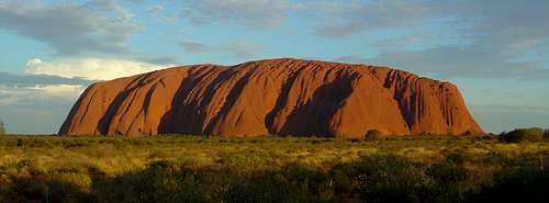
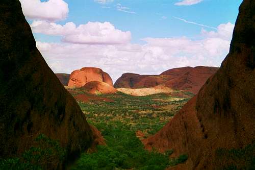
OverviewUluru/Ayers Rock is located in the Uluru- Kata Tjuta National Park in Australia’s Northern Territory. The size of the national park is 1.325 square km and it inhabitats many species of mammals, reptiles, birds, frogs and plants. Uluru (863m high) is made from sandstone which contains iron minerals. Due to water and oxygen the rock gets red (like oxidation of iron). Kata Tjuta (1.066m high) is made of conglomerate.
The National Park is Aboriginal land and partly managed by the traditional owners. They also run a cultural center on the way from the Yulara/Ayers Rock Resort to Uluru. There you have exhibitions about the area, Aboriginal culture and traditional art.
The entry fee for the National Park is 25 AUS$ for adults for a ticket valid for 3 days. Children under 16 are free.
The main attraction is to climb Uluru with its 348 metres above the plain. But the secured climb is often closed due to cultural reasons, wind or high temperatures. As Uluru is of great spiritual significance for Aboriginal people they ask not to climb it.
There is a 9,4 kilometre long walk around Uluru which takes about 3 hours. There are many sacred sites of the Aboriginal people on the way. Near Kuniya on the south side of Uluru there is a waterhole where you can find watersnakes.
On the way to Kata Tjuta there is a short walk along the dunes with a nice view to Kata Tjuta.
At the Kata Tjuta there is the Valley of the Winds Walk which is a 7,4 km long circuit walk taking about 2,5 hours and the Walpa Gorge Walk which is 2,6 km long and takes about 1 hour.
Getting ThereYou can reach Uluru- Kata Tjuta National Park by car on the way from Adelaide to Darwin. There are also planes from mayor Australian cities to Yulara/Connellan Airport and Alice springs. Yulara/Ayers Rock Resort is about 450 road kilometres South- West of Alice springs. AccomodationYulara/Ayers Rock resort offers every type of accomodation from camping to hostels and 5 star hotels. Uluru is about 20 kilometres and Kata Tjuta about 50 kilometres away from Yulara/Ayers Rock resort. External LinksUluru-Kata Tjuta National Park Images
|
|